Automatize GCP image coordinate collection
This is a guest post authored by Zoltán Siki, the creator of the awesome Find-GCP project.
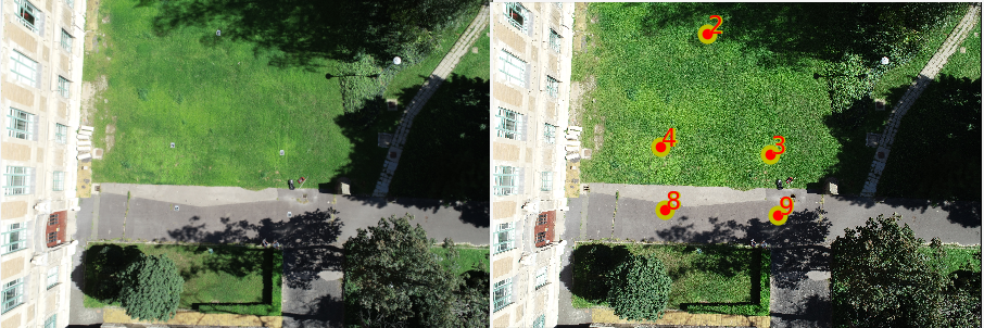
Have you tried to create the gcp_list.txt file for a project with hundreds of images? It is a time-consuming and boring task to find each Ground Control Point (GCP) in 6-10 images and the chance of misidentification are high.
Some pieces of commercial software have an automatic GCP recognition system based on image processing algorithms, but no similar solution can be found in the open-source UAV image processing world.
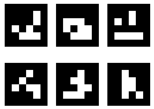
I met ArUco codes some years ago and I used these black and white rectangular markers for indoor navigation and automatic movement detection. When I started to use ODM I realized the same technology can be used to find image coordinates of GCPs. There is a contrib package in OpenCV open-source library to detect marker positions and poses in images. The detection can be automatized using different ArUco markers for each GCP.
At the Geo4All lab of the Department of Geodesy and Surveying at the Budapest University of Technology and Economics a small project was started to implement a solution in Python. The code and some instructions are available on GitHub Its usage is straightforward:
- Install Python3, OpenCV and OpenCV contrib on your machine
- Download the source code from GitHub (zip or clone)
- Generate ArUco markers (aruco_make.py or dict_gen_3x3.py) and print them in a suitable size
- Put the markers on the field before making UAV images and measure coordinates with the necessary accuracy
- Make the flight
- Collect the GCP’s 3D coordinates in a TXT file
- Run gcp_find.py
- Add the generated gcp_list.txt to your ODM project and start ODM processing
Actually there are command line tools plus a simple visual check in the project. A GUI would be a useful addition to the project to edit and review GCP matching results possibly integrated in WebODM. More details are available on the GitHub page of the project and in an article in Baltic Journal of Modern Computing.
Contributions to this project are welcome, usage experience, case studies, bug reports and fixes, enhancements…
99